Create an adapter that takes the list of earthquakes as input.
Set the adapter so the list can be populated in the user interface.
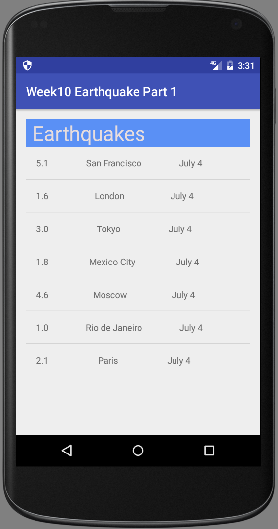
layout_main.xml
  <?xml version="1.0" encoding="utf-8"?>
  <LinearLayout xmlns:android="http://schemas.android.com/apk/res/android"
      android:layout_width="match_parent"
      android:layout_height="match_parent"
      android:orientation="vertical">

      <TextView
          android:layout_width="match_parent"
          android:layout_height="wrap_content"
          android:background="#5a90f5"
          android:text="Earthquakes"
          android:textColor="#e7dddd"
          android:textSize="32sp"
          android:paddingTop="10dp"/>

      <ListView
          android:id="@+id/listView"
          android:layout_width="match_parent"
          android:layout_height="wrap_content" />

  </LinearLayout>
list_item.xml
     <?xml version="1.0" encoding="utf-8"?>
     <LinearLayout xmlns:android="http://schemas.android.com/apk/res/android"
         android:layout_width="match_parent"
         android:layout_height="match_parent"
         android:orientation="vertical"
         android:padding="16dp">

         <LinearLayout
             android:layout_width="match_parent"
             android:layout_height="match_parent"
             android:orientation="horizontal">

             <TextView
                 android:id="@+id/textView1"
                 android:layout_width="wrap_content"
                 android:layout_height="wrap_content"
                 android:background="@drawable/abc_text_select_handle_middle_mtrl_dark"
                 android:text="magnitude"
                 android:textSize="32sp" />

             <TextView
                 android:id="@+id/textView3"
                 android:layout_width="wrap_content"
                 android:layout_height="wrap_content"
                 android:paddingTop="50dp"
                 android:text="Date" />
         </LinearLayout>


         <TextView
             android:id="@+id/textView2"
             android:layout_width="match_parent"
             android:layout_height="wrap_content"
             android:text="location" />


     </LinearLayout>
Earthquake.java
      public class Earthquake {
          public String mag;
          public String city;
          public String mDate;

          public Earthquake(String m, String c, String d){
              mag = m;
              city = c;
              mDate = d;
          }
      }
EarthquakeAdapter.java
       public class EarthquakeAdapter extends ArrayAdapter {
           public EarthquakeAdapter (Activity context, ArrayList earthquakeList) {
               super (context, 0, earthquakeList);
           }

           @Override
           public View getView(int position, View convertView, ViewGroup parent){

               //TASK 1: Check if there is an existing list item view to be recycled.
               // Otherwise, if convertView is null, inflate a new list item layout.
               View listItemView = convertView;
               if (listItemView == null) {
                   listItemView = LayoutInflater.from(getContext()).inflate(R.layout.list_item, parent, false);
               }

               //TASK 2: Find the earthquake at the given position in the list of earthquakes.
               Earthquake currentQuake = getItem(position);

               //TASK 3: find the TextViews in the list item and populate them with data from
               //        the currentQuake data.
               TextView magTextView = (TextView) listItemView.findViewById(R.id.textView1);
               magTextView.setText(currentQuake.mag);
               TextView cityTextView = (TextView) listItemView.findViewById(R.id.textView2);
               cityTextView.setText(currentQuake.city);
               TextView dateTextView = (TextView) listItemView.findViewById(R.id.textView3);
               dateTextView.setText(currentQuake.mDate);

               //TASK 4: return the list item view that is now showing the appropriate data
               return listItemView;
           }

       }
MainActivity.java
        public class MainActivity extends AppCompatActivity {

            @Override
            protected void onCreate(Bundle savedInstanceState) {
                super.onCreate(savedInstanceState);
                //setContentView(R.layout.activity_main);
                setContentView(R.layout.layout_main);

                //Task 1:  Find a reference to the ListView in the layout
                ListView listView = (ListView) findViewById(R.id.listView);


                //Task 2: Create an ArrayList to hold earthquakes
                ArrayList earthquakes = new ArrayList<>();
                // Task 3: Create a fake list of earthquake locations as a JSON string

                final  String SAMPLE_JSON_RESPONSE = "{\"type\":\"FeatureCollection\",\"metadata\":{\"generated\":1462295443000,\"url\":\"http://earthquake.usgs.gov/fdsnws/event/1/query?format=geojson&starttime=2016-01-01&endtime=2016-01-31&minmag=6&limit=10\",\"title\":\"USGS Earthquakes\",\"status\":200,\"api\":\"1.5.2\",\"limit\":10,\"offset\":1,\"count\":10},\"features\":[{\"type\":\"Feature\",\"properties\":{\"mag\":7.2,\"place\":\"88km N of Yelizovo, Russia\",\"time\":1454124312220,\"updated\":1460674294040,\"tz\":720,\"url\":\"http://earthquake.usgs.gov/earthquakes/eventpage/us20004vvx\",\"detail\":\"http://earthquake.usgs.gov/fdsnws/event/1/query?eventid=us20004vvx&format=geojson\",\"felt\":2,\"cdi\":3.4,\"mmi\":5.82,\"alert\":\"green\",\"status\":\"reviewed\",\"tsunami\":1,\"sig\":798,\"net\":\"us\",\"code\":\"20004vvx\",\"ids\":\",at00o1qxho,pt16030050,us20004vvx,gcmt20160130032510,\",\"sources\":\",at,pt,us,gcmt,\",\"types\":\",cap,dyfi,finite-fault,general-link,general-text,geoserve,impact-link,impact-text,losspager,moment-tensor,nearby-cities,origin,phase-data,shakemap,tectonic-summary,\",\"nst\":null,\"dmin\":0.958,\"rms\":1.19,\"gap\":17,\"magType\":\"mww\",\"type\":\"earthquake\",\"title\":\"M 7.2 - 88km N of Yelizovo, Russia\"},\"geometry\":{\"type\":\"Point\",\"coordinates\":[158.5463,53.9776,177]},\"id\":\"us20004vvx\"},\n" +
                        "{\"type\":\"Feature\",\"properties\":{\"mag\":6.1,\"place\":\"94km SSE of Taron, Papua New Guinea\",\"time\":1453777820750,\"updated\":1460156775040,\"tz\":600,\"url\":\"http://earthquake.usgs.gov/earthquakes/eventpage/us20004uks\",\"detail\":\"http://earthquake.usgs.gov/fdsnws/event/1/query?eventid=us20004uks&format=geojson\",\"felt\":null,\"cdi\":null,\"mmi\":4.1,\"alert\":\"green\",\"status\":\"reviewed\",\"tsunami\":1,\"sig\":572,\"net\":\"us\",\"code\":\"20004uks\",\"ids\":\",us20004uks,gcmt20160126031023,\",\"sources\":\",us,gcmt,\",\"types\":\",cap,geoserve,losspager,moment-tensor,nearby-cities,origin,phase-data,shakemap,tectonic-summary,\",\"nst\":null,\"dmin\":1.537,\"rms\":0.74,\"gap\":25,\"magType\":\"mww\",\"type\":\"earthquake\",\"title\":\"M 6.1 - 94km SSE of Taron, Papua New Guinea\"},\"geometry\":{\"type\":\"Point\",\"coordinates\":[153.2454,-5.2952,26]},\"id\":\"us20004uks\"},\n" +
                        "{\"type\":\"Feature\",\"properties\":{\"mag\":6.3,\"place\":\"50km NNE of Al Hoceima, Morocco\",\"time\":1453695722730,\"updated\":1460156773040,\"tz\":0,\"url\":\"http://earthquake.usgs.gov/earthquakes/eventpage/us10004gy9\",\"detail\":\"http://earthquake.usgs.gov/fdsnws/event/1/query?eventid=us10004gy9&format=geojson\",\"felt\":117,\"cdi\":7.2,\"mmi\":5.28,\"alert\":\"green\",\"status\":\"reviewed\",\"tsunami\":0,\"sig\":695,\"net\":\"us\",\"code\":\"10004gy9\",\"ids\":\",us10004gy9,gcmt20160125042203,\",\"sources\":\",us,gcmt,\",\"types\":\",cap,dyfi,geoserve,impact-text,losspager,moment-tensor,nearby-cities,origin,phase-data,shakemap,tectonic-summary,\",\"nst\":null,\"dmin\":2.201,\"rms\":0.92,\"gap\":20,\"magType\":\"mww\",\"type\":\"earthquake\",\"title\":\"M 6.3 - 50km NNE of Al Hoceima, Morocco\"},\"geometry\":{\"type\":\"Point\",\"coordinates\":[-3.6818,35.6493,12]},\"id\":\"us10004gy9\"},\n" +
                        "{\"type\":\"Feature\",\"properties\":{\"mag\":7.1,\"place\":\"86km E of Old Iliamna, Alaska\",\"time\":1453631430230,\"updated\":1460156770040,\"tz\":-540,\"url\":\"http://earthquake.usgs.gov/earthquakes/eventpage/us10004gqp\",\"detail\":\"http://earthquake.usgs.gov/fdsnws/event/1/query?eventid=us10004gqp&format=geojson\",\"felt\":1816,\"cdi\":7.2,\"mmi\":6.6,\"alert\":\"green\",\"status\":\"reviewed\",\"tsunami\":1,\"sig\":1496,\"net\":\"us\",\"code\":\"10004gqp\",\"ids\":\",at00o1gd6r,us10004gqp,ak12496371,gcmt20160124103030,\",\"sources\":\",at,us,ak,gcmt,\",\"types\":\",cap,dyfi,finite-fault,general-link,general-text,geoserve,impact-link,impact-text,losspager,moment-tensor,nearby-cities,origin,phase-data,shakemap,tectonic-summary,trump-origin,\",\"nst\":null,\"dmin\":0.72,\"rms\":2.11,\"gap\":19,\"magType\":\"mww\",\"type\":\"earthquake\",\"title\":\"M 7.1 - 86km E of Old Iliamna, Alaska\"},\"geometry\":{\"type\":\"Point\",\"coordinates\":[-153.4051,59.6363,129]},\"id\":\"us10004gqp\"},\n" +
                        "{\"type\":\"Feature\",\"properties\":{\"mag\":6.6,\"place\":\"215km SW of Tomatlan, Mexico\",\"time\":1453399617650,\"updated\":1459963829040,\"tz\":-420,\"url\":\"http://earthquake.usgs.gov/earthquakes/eventpage/us10004g4l\",\"detail\":\"http://earthquake.usgs.gov/fdsnws/event/1/query?eventid=us10004g4l&format=geojson\",\"felt\":11,\"cdi\":2.7,\"mmi\":3.92,\"alert\":\"green\",\"status\":\"reviewed\",\"tsunami\":1,\"sig\":673,\"net\":\"us\",\"code\":\"10004g4l\",\"ids\":\",at00o1bebo,pt16021050,us10004g4l,gcmt20160121180659,\",\"sources\":\",at,pt,us,gcmt,\",\"types\":\",cap,dyfi,geoserve,impact-link,impact-text,losspager,moment-tensor,nearby-cities,origin,phase-data,shakemap,tectonic-summary,\",\"nst\":null,\"dmin\":2.413,\"rms\":0.98,\"gap\":74,\"magType\":\"mww\",\"type\":\"earthquake\",\"title\":\"M 6.6 - 215km SW of Tomatlan, Mexico\"},\"geometry\":{\"type\":\"Point\",\"coordinates\":[-106.9337,18.8239,10]},\"id\":\"us10004g4l\"},\n" +
                        "{\"type\":\"Feature\",\"properties\":{\"mag\":6.7,\"place\":\"52km SE of Shizunai, Japan\",\"time\":1452741933640,\"updated\":1459304879040,\"tz\":540,\"url\":\"http://earthquake.usgs.gov/earthquakes/eventpage/us10004ebx\",\"detail\":\"http://earthquake.usgs.gov/fdsnws/event/1/query?eventid=us10004ebx&format=geojson\",\"felt\":51,\"cdi\":5.8,\"mmi\":6.45,\"alert\":\"green\",\"status\":\"reviewed\",\"tsunami\":1,\"sig\":720,\"net\":\"us\",\"code\":\"10004ebx\",\"ids\":\",us10004ebx,pt16014050,at00o0xauk,gcmt20160114032534,\",\"sources\":\",us,pt,at,gcmt,\",\"types\":\",associate,cap,dyfi,geoserve,impact-link,impact-text,losspager,moment-tensor,nearby-cities,origin,phase-data,shakemap,\",\"nst\":null,\"dmin\":0.281,\"rms\":0.98,\"gap\":22,\"magType\":\"mww\",\"type\":\"earthquake\",\"title\":\"M 6.7 - 52km SE of Shizunai, Japan\"},\"geometry\":{\"type\":\"Point\",\"coordinates\":[142.781,41.9723,46]},\"id\":\"us10004ebx\"},\n" +
                        "{\"type\":\"Feature\",\"properties\":{\"mag\":6.1,\"place\":\"12km WNW of Charagua, Bolivia\",\"time\":1452741928270,\"updated\":1459304879040,\"tz\":-240,\"url\":\"http://earthquake.usgs.gov/earthquakes/eventpage/us10004ebw\",\"detail\":\"http://earthquake.usgs.gov/fdsnws/event/1/query?eventid=us10004ebw&format=geojson\",\"felt\":3,\"cdi\":2.2,\"mmi\":2.21,\"alert\":\"green\",\"status\":\"reviewed\",\"tsunami\":0,\"sig\":573,\"net\":\"us\",\"code\":\"10004ebw\",\"ids\":\",us10004ebw,gcmt20160114032528,\",\"sources\":\",us,gcmt,\",\"types\":\",cap,dyfi,geoserve,impact-text,losspager,moment-tensor,nearby-cities,origin,phase-data,shakemap,tectonic-summary,\",\"nst\":null,\"dmin\":5.492,\"rms\":1.04,\"gap\":16,\"magType\":\"mww\",\"type\":\"earthquake\",\"title\":\"M 6.1 - 12km WNW of Charagua, Bolivia\"},\"geometry\":{\"type\":\"Point\",\"coordinates\":[-63.3288,-19.7597,582.56]},\"id\":\"us10004ebw\"},\n" +
                        "{\"type\":\"Feature\",\"properties\":{\"mag\":6.2,\"place\":\"74km NW of Rumoi, Japan\",\"time\":1452532083920,\"updated\":1459304875040,\"tz\":540,\"url\":\"http://earthquake.usgs.gov/earthquakes/eventpage/us10004djn\",\"detail\":\"http://earthquake.usgs.gov/fdsnws/event/1/query?eventid=us10004djn&format=geojson\",\"felt\":8,\"cdi\":3.4,\"mmi\":3.74,\"alert\":\"green\",\"status\":\"reviewed\",\"tsunami\":0,\"sig\":594,\"net\":\"us\",\"code\":\"10004djn\",\"ids\":\",us10004djn,gcmt20160111170803,\",\"sources\":\",us,gcmt,\",\"types\":\",cap,dyfi,geoserve,impact-text,losspager,moment-tensor,nearby-cities,origin,phase-data,shakemap,tectonic-summary,\",\"nst\":null,\"dmin\":1.139,\"rms\":0.96,\"gap\":33,\"magType\":\"mww\",\"type\":\"earthquake\",\"title\":\"M 6.2 - 74km NW of Rumoi, Japan\"},\"geometry\":{\"type\":\"Point\",\"coordinates\":[141.0867,44.4761,238.81]},\"id\":\"us10004djn\"},\n" +
                        "{\"type\":\"Feature\",\"properties\":{\"mag\":6.5,\"place\":\"227km SE of Sarangani, Philippines\",\"time\":1452530285900,\"updated\":1459304874040,\"tz\":480,\"url\":\"http://earthquake.usgs.gov/earthquakes/eventpage/us10004dj5\",\"detail\":\"http://earthquake.usgs.gov/fdsnws/event/1/query?eventid=us10004dj5&format=geojson\",\"felt\":1,\"cdi\":2.7,\"mmi\":7.5,\"alert\":\"green\",\"status\":\"reviewed\",\"tsunami\":1,\"sig\":650,\"net\":\"us\",\"code\":\"10004dj5\",\"ids\":\",at00o0srjp,pt16011050,us10004dj5,gcmt20160111163807,\",\"sources\":\",at,pt,us,gcmt,\",\"types\":\",cap,dyfi,geoserve,impact-link,impact-text,losspager,moment-tensor,nearby-cities,origin,phase-data,shakemap,tectonic-summary,\",\"nst\":null,\"dmin\":3.144,\"rms\":0.72,\"gap\":22,\"magType\":\"mww\",\"type\":\"earthquake\",\"title\":\"M 6.5 - 227km SE of Sarangani, Philippines\"},\"geometry\":{\"type\":\"Point\",\"coordinates\":[126.8621,3.8965,13]},\"id\":\"us10004dj5\"},\n" +
                        "{\"type\":\"Feature\",\"properties\":{\"mag\":6,\"place\":\"Pacific-Antarctic Ridge\",\"time\":1451986454620,\"updated\":1459202978040,\"tz\":-540,\"url\":\"http://earthquake.usgs.gov/earthquakes/eventpage/us10004bgk\",\"detail\":\"http://earthquake.usgs.gov/fdsnws/event/1/query?eventid=us10004bgk&format=geojson\",\"felt\":0,\"cdi\":1,\"mmi\":0,\"alert\":\"green\",\"status\":\"reviewed\",\"tsunami\":0,\"sig\":554,\"net\":\"us\",\"code\":\"10004bgk\",\"ids\":\",us10004bgk,gcmt20160105093415,\",\"sources\":\",us,gcmt,\",\"types\":\",cap,dyfi,geoserve,losspager,moment-tensor,nearby-cities,origin,phase-data,shakemap,\",\"nst\":null,\"dmin\":30.75,\"rms\":0.67,\"gap\":71,\"magType\":\"mww\",\"type\":\"earthquake\",\"title\":\"M 6.0 - Pacific-Antarctic Ridge\"},\"geometry\":{\"type\":\"Point\",\"coordinates\":[-136.2603,-54.2906,10]},\"id\":\"us10004bgk\"}],\"bbox\":[-153.4051,-54.2906,10,158.5463,59.6363,582.56]}";
                try {
                    // Parse the response given by the SAMPLE_JSON_RESPONSE string and
                    // build up a list of Earthquake objects with the corresponding data.

                    //TASK 4: CREATE A JSONObject from the SAMPLE_JSON_RESPONSE string
                    JSONObject baseJsonResponse = new JSONObject(SAMPLE_JSON_RESPONSE);

                    //TASK 5: Extract the JSONArray associated with the key called "features",
                    //        which represents a list of features (or earthquakes).
                    JSONArray earthquakeArray = baseJsonResponse.optJSONArray("features");

                    // TASK 6: For each earthquake in the earthquakeArray, create an {@link Earthquake} object
                    for (int i = 0; i < earthquakeArray.length(); i++) {
                        //SUBTASK A: GRAB THE CURRENT EARTHQUAKE OBJECT AND EXTRACT THE THREE COMPONENTS
                        JSONObject currentEarthquake = earthquakeArray.getJSONObject(i);
                        JSONObject properties = currentEarthquake.getJSONObject("properties");
                        String magnitude = properties.getString("mag");
                        String location = properties.getString("place");
                        String time = properties.getString("time");

                        //SUBTASK B: ADD AN EARTHQUAKE OBJECT TO THE ARRAYLIST
                        earthquakes.add(new Earthquake(magnitude, location, time));
                    }

                    // Task 7: Create a new "custom" adapter that takes the list of earthquakes as input.
                    EarthquakeAdapter itemsAdapter = new EarthquakeAdapter(this, earthquakes);

                    // Task 8: Set the adapter so the list can be populated in the user interface
                    listView.setAdapter(itemsAdapter);

                } catch (JSONException e) {
                    Log.e("QueryUtils", "Problem parsing the earthquake JSON results", e);
                }


            }

        }
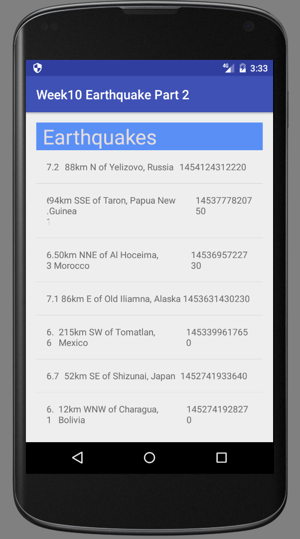
For example, create a fake list of earthquake locations as a JSON string. Parse the response given by the JSON string and build a list of Earthquake objects with the corresponding data. Create a JSONObject from the JSON response string and extract the JSONArray associated with the key called "features". NOTE: "features" represents a list of earthquakes.